|
How to Understand, Observe and Document Severe Thunderstorms Safely.Your home weather station can reveal the secrets of the growth, behaviour and decline of thunderstorms. Air masses that have formed over oceans or seas contain plentyof moist air, and the major sources of moist air for most of the USA move landward from the Atlantic Ocean or Gulf of Mexico. Instability simply means that if air is given some help to rise or fall, it will continue to do so independently of the initial cause.
And the initial cause of rising air, or lifting mechanism, can be convection caused by differential heating of the land surface, or warm air being forced to rise over the boundary between moving masses of air of different temperature and moisture content, most frequently a cold front.
Of course, the absolutely indispensable feature of thunderstorms is Lightning - the rapid heating of air as lightning discharges causes a shock wave, the sound of which we hear as lightning.
Single Cell Thunderstorms
Different parts of the earth's surface heat up at different rates- for instance a ploughed field will heat faster than one covered in vegetation, and land will heat faster than water. Differential heating creates thermals - rising columns of air - over the warmer areas, and if the air is both moist and unstable a single cell thunderstorm may develop.
Like all thunderstorms, single cell storms have the potential to be dangerous, but in most cases they make a bit of noise, bring some useful rain and temporary relief from the heat, and decay quite rapidly.
On several occasions I have been fortunate enough to watch a solitary thunderstorm form above me. The weather had been hot and humid, with scattered cumulus but mostly clear skies. Then one cloud, almost directly above me, started to grow and darken - on this and other occasions occasions the growing cloud was above an area of bare rock which, being hotter than the surrounding ground, probably was responsible for a small thermal.
As the cloud grew, other small cumulus clouds surrounding it shrank, as if their moisture was being transferred to the building cloud. After a while, as the cloud spread and grew, muffled thunder could be heard. Light rain started, and it appeared that just a light shower would be all that would happen, but the cloud continued to build. It grew darker, and the rain became heavy. All the while, it was obvious that the sun was shining brightly elsewhere, and before long, the rain eased, the cloud lightened, and soon disappeared.
In these circumstances, the storm stayed in the one place, raining itself out rather than moving on. It is quite likely that the rain, in cooling the bare rock areas, removed the source of the thermal which started the growth of the storm.
While these storms are usually mild, they can present a few problems.
Another experience I had was while driving along a rough track which required all my concentration. Most of the time I was in mid afternoon sunlight, and it wasn't until the first few heavy raindrops made craters in the dust of the track that I realised that a small thunderstorm had formed above me - not large enough to block the sun half way down the western sky. Again, although the initial rainfall seemed like a brief shower, the storm was still growing and heavy rain began and lasted about 40 minutes. It was enough to produce flash flooding, where the small gully beside the road changed from dry to a three foot flood of turbulent muddy water within minutes. About 20 minutes after the last of the rain the sky had cleared to scattered fair weather cumulus, and there was no more rain that day.
Multi-cell Thunderstorms
Quite often thunderstorms will form in clusters of cells, which grow and dissipate at different rates while merging together. These more active storms extend over larger areas and can last for several hours. Highly active Multi-cell storms can produce large hail, strong winds, cloud to ground lightning, flash flooding, and isolated tornadoes.
Squall Lines
Further up the scale of severity are storms which develop in lines along a front. The strong lift along the front provides the impetus for storm formation, which, once in progress, can be self perpetuating as rain-cooled air spreading out in front of the storm acts as a mini cold front, lifting warm humid air above it to further feed the storm.
These squall lines can move very rapidly and last for hours. During their life the damaging winds, heavy rain and large hail can affect large areas. Downbursts and strong straight line winds, including derechos are common, and tornadoes may also form.
Supercells
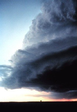
The junk yard dog of the thunderstorm world is the supercell. It is a giant single cell storm which can last for many hours. The energy involved is immense, as vast amounts of humid air are drawn into the system, to return to the ground as very heavy rainfall and large damaging hail.

Supercell approaching Miami Tx, 1980,
These highly active storms generate very strong winds, and are typified by a strong, usually cyclonic rotation pattern (anticlockwise in the northern hemisphere, clockwise in the southern). Rotation frequently results when winds at altitude are from a different direction to those at the surface.

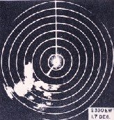
Supercell on Radar from 1945 Rotation of the system can be seen in the clouds themselves and on radar. Under the right conditions tornadoes can form - almost all significant and highly destructive tornadoes are formed in supercells. Click Here For Your Free 20 Page Report on Solving Thunderstorm Distribution Depending on where you are in the USA, you can expect up to 100 days each year during which thunderstorms will form. With the exception of the west coast, almost everywhere will experience 20 or more days with storms, while 100 days with storms is to be expected in Florida. So the chances are that several times a year a thunderstorm of some form will pass close to or over your home. Thunderstorm Observation Unless you feel that just being in the path of a thunderstorm provides more than enough interest on its own, there are a number of things you can do to raise the level of your experience, particularly if your home weather station has good data saving capability. Bear in mind that thunderstorms can be severe and destructive. I need all the readers I can get, so do take the time to check the weather warnings - a Weather Radio is an excellent investment - and do whatever is necessary to protect life and property.
If you can record wind speed, wind direction, and rainfall, you have the opportunity to follow all facets of thunderstorm growth, maturity and decline. What changes do you see in temperature, humidity and air pressure as the storm approaches and passes?
Is there any difference in the sequence between a single cell thunderstorm and a squall line?
And what can you tell about wind speed and direction during the various stages - how does this relate to peak rainfall and thunder and lightning intensity?
If the storms are associated with frontal activity, is your storm close to the front, or in advance of it?
There are many more possibilities in recording the passage of a storm, including visual observation and linking of your records to radar and satellite imagery.
Perhaps on some occasions you may be a little more adventurous - these links will provide information on Storm Spotting and Chasing. I'm still working on these pages - bookmark this page and check again later.
If you would like to know more about Home Weather Stations , please follow this link. And here is the link to the Severe Weather page. Back to the Top, or return to the Home page.
You may be interested to know that you can find out more about weather and home weather stations by receiving our newsletter ,"Watching Weather". It's published more or less weekly, and apart from tips on how to use your weather station and understand what it's telling you about the weather around you, it also covers many other weather related topics. If this sounds interesting, just add your name and email address to the form below. When you join, you'll also receive, totally free, a 20 page guide to setting up and trouble shooting problems in home weather stations. And I promise that you won't get spammed, and that your sign up details will remain totally confidential. Sign up now and receive your first issue almost immediately. Last update 05/28/2011
|


